Sunday, May 29, 2011

Charleston to Cape Lookout


The Cruiser Babe is ready to go. Blue, pink, yellow, and orange do match, so long as you wear a man watch. Isn't she cute? 

At midnight, on the eve of our departure from Charleston, we changed our destination from Cape Lookout to the Poquoson River just inside the mouth of the Chesapeake. Our route would be just under 500 NM and take 4 days and 3 nights give or take. Rounding Hatteras and a Friday departure sounded like a good combination. The forecast looked good and we knew we could always bail out so long as we did it before passing Cape Lookout.

Friday morning we tried to listen to Chris Parker on the SSB one last time, but propagation was terrible as it had been all week, so we got no help from him. We checked Passage Weather and Sail Flow and the forecast still looked good, however hints of possible scattered squalls started to surface.

Prior to our departure, we had endured a couple of bouncy nights at anchor but it didn't get any better after weighing anchor. We waited until 9:30 am to up anchor to ensure a daytime arrival at the Chesapeake. We can run the ship channels in the Chesapeake at night, but the bay is infested with crab pots, so we prefer to have daylight.

With the wind against tide, leaving the Charleston Inlet was quite rough. We thought conditions would improve once we left the channel, but it turned out to be a rough passage. All the models predicted 2 to 4 foot seas but it was not to be.

We sailed until 3 the following morning with all 3 sails and the main slightly reefed. The wind was more from the east than was forecast, which put us on a close reach (wind forward of the beam) instead of a broad reach (wind aft of the beam) or a run (behind the boat). In our lake sailing days, I loved close reaching or close hauled sailing, but with 5 to 6 foot swells on the beam it's not so much fun.

At 3 the wind died, so it was motor sailing for the rest of the trip. With the swells on our beam we were like a Grandfather Clock sans cuckoo bird for the whole trip.

We enter our latitude and longitude into our log every hour on the hour like they did in the old days. That way, when the Chinese finally decide to shoot down our satellites, we have a reference to plot our position on our paper charts. It will also be helpful if lightning knocks out our GPSs.

Nightfall brought with it a spectacular view of the stars. It didn't take long before lightening started to chase us from behind, then on both sides, and eventually appeared in front of us as well. It was still clear above us with the stars as beautiful as ever. As I've said before, with our 57 foot mast, I'm mucho scardo of lightening, but it did not pounce on us.


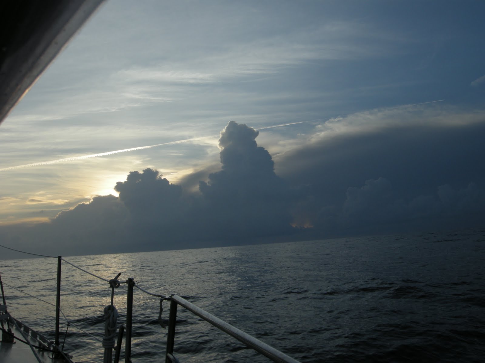
Sunrise exposed the clouds to our east that threatened all night.


A tad bit of instability.


We found some shade. Who needs a bimini?

After rocking and rolling all day and night, and with the unstable atmosphere, we easily convinced ourselves to not round Hatteras this time around. So, after checking weather again, we decided to alter course and head for Cape Lookout.


A little birdie told me... OK, what's with these birds? This guy did not die on us. He flew off after a couple hours of rest. We could not offer him water because it was too rough. The picture looks calm, but the swells were knocking us around pretty good. 

We had another one stay with us on our way from Ft. Pierce to Charleston. That trip was calm, and he bathed in the water we provided him, then flew off. Lisa thinks she can restore her baby bird sitting resume to good standing. Hard to do when one died on you though.
When we finally made it to our anchorage, our worst fears were realized---holiday weekend + nice anchorage + close to several cities = lots of boats. I know my consumer math. But it is a large anchorage, and our anchor was down at 11:30 pm.

Wednesday, May 25, 2011

Stuart to Charleston

Nasty wind and rain greeted us upon our arrival back at the marina. Our rental car was full of Costco purchases, so we were relieved that the rain let up just long enough for me to coax the marina manager to shuttle me to our boat so that I could retrieve our dingy. By the time I made it back to the dinghy dock it was raining again, so we killed several hours in town to give the weather a chance to move out. This made for a late night, but we were thankful that the rain finally did move on.

On Monday morning we dropped off a weathered Stars and Stripes at the local Ace Hardware store, returned the rental car, made one last stop at Publix, dropped the mooring line and headed for Fort Pierce.

The forecast called for a week of perfect trawler weather--beautiful with light winds. We wanted to go straight from Ft Pierce to Cape Lookout (which is just a few miles past the inlet at Beaufort, NC ) and in fact started out on that route, but then thought better of it and headed to Charleston, SC instead.

The problem was fuel. Our large tank was nearly empty and the smaller one was only half full (the last time we fueled up was early December in Daytona--how about that one stink potters. Remember that when you leave us in your wake).

Fuel prices vary widely on the East Coast now. Sometimes there's an 80 cent per gallon difference. Florida has recently added an extra 7 or 8 cent per gallon tax for pleasure boats, so we determined we would fuel up somewhere else since we could. That and the lack of wind in the forecast (no sailing) forced us to hang a left at Charleston.

The anchor was up at first light Wednesday and we had delightful weather throughout. The first night, the wind made an unexpected appearance for 8 hours and we enjoyed a lively 8-9 knot sail--with a little help from the Gulf Stream. At 2 am the wind died, but we picked up speed as we moved closer to the center of the stream. With the engine running at low rpms, we were doing 10 and 11 knots. The center of the GS is not in the same place everyday, so unless you have access to a forecast that gives you up to date latts and longs of it's current position, you are only guessing at it's speed and location.

Because we caught more of the stream than anticipated, we had to slow down our slow boat for the final 18 hours. We needed to keep our average speed at 5 1/2 knots or less for the remainder of the trip. This was so we didn't arrive at the Charleston Inlet before first light, although I won't worry about that in the future. It's a very easy inlet and channel. Plus, if you anchor when everyone else is asleep, you don't have to endure their "don't anchor too close to me" glares.

On our second afternoon out, we were in the process of making water (actually converting very salty water into delicious much much less salty water--the best tasting water there is, by the way) when Lisa reported the alarm on the watermaker was blinking. After a couple of attempts to restart it failed, Lisa noticed our bilge pump was spitting water out to the sea. After checking the engine room, I could see the leak was coming from somewhere behind the engine and stuffing box (where the prop shaft comes into the boat). Of course, that's where the main part of our watermaker is located, so it was time to empty the lazerette so that I could crawl down there and investigate. It was nice that the conditions were calm.

I assumed that a hose on the watermaker had burst open, but it ended up being the end cap to the tube that holds the membrane (where the high pressure pump blows the sea water and the membrane stops most of the salt, which is then flushed overboard). A chunk of the hard plastic had literally blown off the tube. After calling the watermaker company, they said there was a batch of bad end caps around the time ours was made, so they are shipping us 2 new end caps since the other side may be defective as well.


With the help of a mirror, you can see the hole where the high density plastic blew out. 

I don't think we were ever in any danger. The water stopped flowing when the watermaker shut down (and after we quit trying to restart it), but we shut the intake through hole, reloaded the lazarette, and continued on our way.


Lisa woke me from an afternoon nap to watch a large pod of dolphins playing off our bow. It was sunny and calm with clear water so it was a treat to watch them dart around. They made several appearances over the 2 days and nights we were out.


Now, that is calm water.


Steeple in Charleston.

While in the Charleston anchorage, we were reunited with fellow Texans Rick and Linda. It was good to see them again. They just sold their Catalina and purchased a catamaran. We got to be the first dinner guests on their new boat.

Day one at the city anchorage was uneventful. Day two was not. Charleston has a 6 foot tide, and the anchorage has a very strong current. In calm weather this is not a problem--the holding is very good. When the wind pipes up and goes across the current, it gets interesting. That's when boats start doing a white man dance--all out of sync.
In a normal anchorage, boats generally swing together--more or less. In anchorages with strong currents, skippers need to allow for more room. The total scope of your boat's rode and the rode of any boat around you plus maybe another million feet.

On our second day, a boat anchored too close to us, and then the wind piped up. We ended up fending them off several times. Turns out he had a fuel pump he was trying to fix. It became apparent that would not happen soon enough, so we weighed anchor, and moved a couple of miles south away from other boats.

We reanchored at the city a couple days later so that we could do laundry and pick up our watermaker parts, but then returned to our more secluded anchorage for the night.

We had the watermaker parts overnighted from California. Since we needed them pronto, they had us pay shipping, but not for the parts. After a day of bending every which way, and basically hurting all of my muscles and bones, the water maker is operational again--at least it passed a 6 minute test. We won't know for sure until we run it for a few hours.

When the weather settles, we will head to Cape Lookout. If the weather is nice, we may go around Hatteras and up into the Chesapeake.

Monday, May 9, 2011

Adios Bahamas

Marsh Harbor has by far the best grocery store we have seen anywhere in the Bahamas. It is very much like most grocery stores you would find in the US of A, except they are sorely lacking in the chocolate department. While the prices are higher than the US, they are much more reasonable than anywhere else we've been in the Bahamas.

While leaving Maxwells, we could see some pretty serious smoke coming from a nearby neighborhood. It turned out to be a tragic day for many, as 25 homes were lost to the fire.


A view of the smoke from the anchorage.


At 6:30 pm, we upped anchor and headed for Matt Lowes Cay. Lisa and I had spent a good part of this very warm day hiking around and past Marsh Harbor. We kind of over did it in the heat and we desperately wanted to swim to cool down. But it was well into shark dinner time so we settled on showers instead.


HEE HEE. For those of you from Rio Linda, that is signature Michael Jackson. Lisa claimed to be doing yoga on the beach, but sure looks more like MJ to me.


Yoga is so easy. Ummm.

After a couple of nights at Powell Cay we spent most of a day sailing to Double Breasted Cays. This is our favorite spot in the Abacos. It's far enough off the beaten path that it doesn't get too crowded. The guide books say the area is known for shark sightings (what area in the Bahamas isn't?). But if you can work up the nerve to jump in it is a great place to snorkel and spear fish. I finally got a grouper there.

Our plan was to make the jump to Florida from here, and my intent was to scrub the prop and clean the bottom one last time before our crossing. The only problem was that a 4 foot barracuda was hanging around under our boat. We were there for 3 days and so was he.

We have swum around a lot of barracudas, and generally they don't bother you. The books say most attacks involve spear fishing (why else would you snorkel?) or if they mistake shiny clothing or jewelry for a fish. Like a shark mistaking a surfboard for a seal. I love how they always say the animal didn't mean to do it. They don't get fat because they didn't mean to. They are predators. The books also say if you try to spear a barracuda or a shark they will attack you. Better not miss. That takes them off my target list.

Another thing the books say is that barracudas chop larger fish in half and then eat the pieces. So I didn't do a final scrub on the prop or bottom of our boat.

It was time to head back to Florida because we were out of chocolate. I was reduced to inhaling chocolate milk mix out of the packet (the only reason we had that was to mix it with an absolutely horrible vitamin mix we had to drink--only way I could get it down).

We left Double Breast Cays at 11 am on a Friday. We had a wonderful sail across the bank, first on a dead run with just the genoa, then with the wind just aft of a beam reach with all 3 sails up. The light wind was supposed to clock slowly from the east through south and then finally west (on the nose) right before arriving at the Ft. Pierce inlet. We are too yellow to enter St. Lucie Inlet--shifting bars and too shoal for our comfort.

For whatever reason, the banks have hazards on their edges, so you can't just exit wherever you want. We were originally going to exit at Mantanilla Shoals, but decided to go another 11 1/2 miles south to the White Sand Shoals to get a better wind angle for when we approached the Florida coast.


Near the edge of the bank. Our last Bahama sunset as we bid the turquoise waters adios.


30 seconds later.

We had a wonderful sail nearly all the way to Florida with all 3 sails up. The winds were supposed to be too light for sailing, but that was not the case. The big problem was they clocked to the west far sooner than forecast. This forced us to sail further north than we wanted. The Gulf Stream makes that a double whammy because it pushes you north really fast and thus further in the wrong direction. You can't tack south into the stream unless you like hove to speed. So we ended up almost 20 miles north of Ft. Pierce at which point I had hoped we would be out of the Gulf Stream and could tack back southwest for a normal sail. By that time we were still in the stream and about to run into thunderstorms to the north, so we went ahead and tacked to the southwest. We don't like hove to speed so we turned on the motor and motorsailed due west straight into the wind until we got out of the river. Then we were able to turn southwest and head for the inlet. The water temp in the stream was 81 degrees, and it was 72 degrees when we got out of it near the coast.

It would have been faster and easier to motorsail as soon as the wind went west and just do the rhumb line, but we really wanted to sail the whole way. Then we got tired and I really missed my chocolate.

This is the sixth time we've crossed the Gulf Stream, and we've gone a different route each time. None of them are my favorite. I would just as soon have a Jeanie blink us back and forth. I do prefer crossing in the daytime.
After entering the inlet at Ft. Pierce, we headed south on the ICW another 30 miles or so to Stuart where we will leave the boat for a few days to visit Mom and Carol.

Hopetown

We had a good time sailing in the Abacos. To the east, you have several cays which protect you from the swells, waves and the long fetch of the Atlantic Ocean. It can get a bit squirrelly in between the cays, but no big deal. To the west you have Great Abaco and Little Abaco to keep the waters from that direction quiet. So for the most part, it's like sailing on a big lake with the benefit of the wind and protection from the waves.

To get from the Central Abacos to the Southern Abacos (no great distance involved) you have to go outside into the Atlantic, get around Whale Cay, and then reenter just north of Great Guana Cay. Everyone freaks out about this section. Basically, the very deep Atlantic suddenly becomes relatively shallow near Whale Cay. When the waves and swells hit this shelf big rollers develop. Even if the wind is calm locally, this area can become untenable (the locals call it a rage). With the very long fetch, this area can suffer the affects of storms from a couple thousand miles away. We passed through this area in nice weather 3 or 4 times with no problems, but it was always a bit sloppy.


A fuel barge at Orchid Bay Marina on Great Guana Cay.


The Queens Highway in Hopetown.


My queen on The Queens Highway on Man of War Cay.


Back at Hope Town, Lisa nearing the intersection of Lady Di Blvd and Prince Phillip Ave.


The famous Hopetown Lighthouse.

Sunday, May 8, 2011

Back to Man of War and Powell Cay


Lisa and I were prepared to make an offer on this beach house until we saw it's name. That's when we remembered we don't have any money. So I guess we won't be living on Man Of War Cay.


After hiking most of Man of War Cay, we came upon this cage. Not exactly a zoo, but perhaps with a few more subjects....


OK. They got us.  Love it.


Watching a baseball game by the Atlantic Ocean.


The clouds in this sunset look like a UFO is about to land. This was while at anchor near Powell Cay.