Tuesday, November 30, 2010

St. Augustine with the Hooooooootons


Randy, Lisa and Carla guarding the inlet from their perch at the fort.


Randy and Carla Hooooooton took us to a drive-in church in Daytona in their Hootmobil.


Beauty and the Beach. Is this a great shot of the surf or what?


The other side of the same wave.

Here's a much better view. Carla, Randy, Lisa. For 5 bucks you can drive on the beach at Daytona.

We had a great time with the Hootons, and it was sad to see them leave--all the way back to Texas.

St. Marys, Fernandina Beach, St. Augustine

We stayed in St. Marys for a week or so soaking in the quiet laid back pace of life of the locals.


Foggy morning at anchor. The birds were not bothered.


A typical street complete with moss covered oak trees and the sounds of silence.

From St. Marys we made the short hop to Fernadina Beach, where we spent another week. The next leg was to the historic city of St. Augustine. This was a day trip down the ICW. The only hitch was when we got to the Bridge of Lions in St. Augustine, the tender could not get the bridge to lift up. But this was not New Orleans, so they had it working within 30 minutes.

St. Augustine recently installed a mooring field, which in effect eliminated most of the available anchorages. We rented a mooring for the week of Thanksgiving.

Randy and Carla did it again. They made the long drive from Texas to Florida to spend Thanksgiving with us. How great is that?


Lisa and Carla making the pier look good.


Friends with Friends.  When with Carla, act like Carla...


Not the oldest teacher in America--the oldest wood schoolhouse in America.  Please get that right.

Tuesday, November 9, 2010

Wrightsville Beach, North Carolina to St. Marys, Georgia

We ended up staying in Wrightsville Beach for a week or so and enjoyed our stay. There is a nice and very long beach where we took several long walks. We also made numerous ventures to the not so close grocery store and surrounding shopping centers.

The sailing vessel Serena showed up at the anchorage for a couple of days, and we were able to spend an evening with them. It was nice to see George and Terry again.

We witnessed an incredible number of boats pass through the area on their way to warmer weather. This can cause a bit of stress on a daily (afternoonly) basis, as some boats tend to get a bit too cuddly. Strong currents and wind make boats do funny things at anchor and the spacing needs to be a bit more generous than if you are just laying to the wind.

Our plan was to go offshore to Charleston and spend a few days there. The anchorage in Charleston isn't the greatest (we have passed through but not anchored there yet), and after witnessing the heavy traffic heading south, we decided to try Charleston on our way north when the traffic is a bit thinned out.

So we made a last minute decision to go offshore to St. Simons Island, Georgia. This would involve 2 nights at sea. The forecast was for winds 15 to 25 knots off our stern, and gave us 48 hours before it would clock around to our nose.

So like all good sailors, we weighed anchor on a Friday--once again. We left a little after 10 am to take advantage of a fair current through Snows Cut (we went 9 knots through the cut), and had minimal foul current down Cape Fear River.


Our boat is not named Noah's Ark, but for the second offshore in a row we had a visitor. This was a baby and totally exhausted. He toured our boat several times from bow to stern. He would walk over my feet and even hopped into my hand.


Three times he did head stands inside the cockpit drains and I had to pull him out by his tail.

When Lisa came up from her off watch, she brought a lid with water in it, but like Confucius said "you can lead a bird to water, but you can't make it drink."


It was windy and rolly and the bird had a hard time staying in place, so Lisa got one of her hats and put a rag in it. Then we got the bird to settle down in his new luxury home, complete with cracker crumbs. We couldn't find any worms or bird seed on the boat. That's a good thing...

This global warming has to stop. It's confusing the birds, and now they are flying north in the winter instead of south.

If this poor thing had missed us, his next chance would have been that floating block of ice with the marooned polar bear on it.

The following morning when I came up to relieve Lisa from her watch, I was informed that the bird almost made it through her watch, but not quite. We are now minus a bird, a hat, a rag and a cracker.

While Lisa has my full support, I have to admit this doesn't look good on her babysitting resume.

For estimating arrival time at the inlet of our destination, I jot down possible arrival times based on half knot increments from 5 knots to 7 1/2 knots of speed. Then we time our departure to ensure we don't arrive while it's still dark. If we go slower, we have the rest of the day to arrive. This time we left a bit earlier than normal so that we didn't have to fight the very strong currents in Snows Cut and the Cape Fear River. We had to transit these to gain access to the Atlantic.

We had another incredible sail all through the first day and night then into the following day. We were able to sail faster and longer than expected. When dusk approached on the second day, the wind finally died down to nothing and we resorted to the engine. It was just as well, because we needed to slow down anyway--we should have left Wrightsville later than we did. Motoring slowly (I'm talking slowly for a sailboat) through the second night was agony.

Once the sun decided to appear on the 3rd morning, we made our way through the inlet and on up to the Frederica River. Like most anchorages in the region, big tides and strong currents are the rule. Strong currents aren't that big a deal if the weather is calm, but when the wind pipes up it's not so much fun. While the wind will more or less blow from one direction, the current does a 180 every 6 hours or so. When the wind and the current are in harmony it's not bad, but when they oppose each other...like I said, not fun.
We had a couple of beautiful, calm days after arrival, and we took full advantage of that to explore the southern part of St. Simons Island. Though small, we really liked the town, and it was well worth the 3 mile walk (one way) under the moss laden oak trees which provided a canopy for a good portion of the way.


You get a good view of this lighthouse when entering St. Simons Inlet.


Anchor Babe.


Our boat boat is not aground, it really is in water. This was taken from the bridge on the way to the island. Much of this region has numerous rivers and creeks surrounded by this grass. At high tide the water is well above the bottom of the grass.

After our beautiful days, we had some cold,windy and nasty days, but that's all part of it. When the forecast was favorable, we made an outlet out of the St. Simons Inlet and made our way to St. Marys, Georgia. It was cold, but we had a very nice day sail (with lots of dolphins) until we reached the St. Marys Inlet, then we turned on the motor for the short trek up the river. No birds this time. Our hats are safe.
We are right at the Georgia/Florida border---a seasoned redneck could spit on Fernandina Beach, but a southern belle would want a car. If the wind is right, everyone can benefit from the aroma the near by pulp plants emit.

The people of St. Marys are some of the nicest you will ever meet. This is our second visit to this quiet, friendly town and it is a poster for southern hospitality.

Thursday, October 28, 2010

Belhaven to Wrightsville Beach


On our approach to Belhaven, we discovered that our dripless shaft seal was about as dripless as our stainless steel is stainless. The shaft seal is the thingy that is supposed to keep water from intruding into the boat through the hole where the shaft enters the boat from the propeller on the outside on it's way to the engine on the inside.

This would involve hauling the boat out of the water, pulling the shaft partially out, sliding a new seal (and also a spare) onto the shaft, then reattaching the shaft, realigning the engine, putting it back in the water, and paying the bill with a smile.

We ordered the seals and set up an appointment with Bock Marine which is not far from Beaufort, NC. After leaving Belhaven, we anchored for the night in Back Creek , a tad north of Oriental.

The following morning our anchor was up by 5, very dark...and it was foggy. The entrance to the creek has several sharp turns to avoid shoals and we would not have attempted it in the dark and fog without radar and a chartplotter. Once we got out into the Neuse River the fog got thicker. We were going slow and on the verge of turning around to reanchor in the creek, but we decided to proceed past South River before giving up on the day. We did not want to enter the Adams Creek part of the ICW with thick fog. After passing South River the fog lifted and it turned into a beautiful day.


Fishing boat on Adams Creek ICW.


We arrived at Bock Marine just before 9 am, and we were out of there by 2:15. They seemed to do good work, but it's the first time we have ever been charged 42 feet for our 40 foot boat.

We like the town of Beaufort, but the anchorage is waaaay too crowded for us and the marina is very expensive with 3rd world quality restrooms and showers. So we continued on out the inlet, hung a left and made our way to Cape Lookout Bight. Our anchor was down before 5 pm. Cape Lookout Bight is an easy place to make a departure in the dark which suited us well. Our next stop was Wrightsville Beach which would be a long summer day sail--but this wasn't summer, so we would need to leave in the dark.


Pretty boat anchored next to us at Cape Lookout Bight. Notice the bike on deck.

We stayed put for a day waiting for the wind to change direction and to take advantage of a cold front which would bring brisk but favorable winds. We were underway by 4 am with 20 to 25 knot true wind just off our stern. The winds were supposed to abate through the day--which they did, but they stayed brisker than the forecast which enabled us to sail more and make a fast passage.


Sometime late morning, we picked up this very tired passenger.

We made good time and were anchored near the bridge at Wrightsville Beach by early afternoon.


The Motor Vessel Mi T Mo anchored behind us. Notice the car and the carport on the foredeck.

Tuesday, October 12, 2010

Portsmouth to Belhaven

We were weighing anchor by 5 o'clock Saturday morning ready to take on mucho restricted bridges and a lock. Half way through the weighing anchor process our chain brought up a 5 foot long pipe off the bottom of the Elizabeth River. A couple of days worth of reversing currents had wrapped our chain around the pipe, tying a pretty good knot around it. Of course that section of chain and the pipe were caked with yucky mucky gross mud--and I had been feeling all nice and clean and ready to go. Ten minutes later I wasn't feeling so clean anymore and neither was the front deck of the boat. But we were on our way.

We had left early in hopes of beating the crowd to the lock, but got held up a long time waiting for a train. That gave everyone a chance to catch up, so we basically got up early for nothing, but the weather was perfect.


Bow Babe on duty at the lock.

We wear our life jackets at the lock so that we don't get yelled at in case we have to get off the boat to secure it.


These boats are tied up at the town of Great Bridge, which is just after passing through the lock. There is good provisioning here, but we have yet to stop. We are usually stocked up at this point and it tends to get very crowded here.


Later in the day we sensed that something had passed us. We couldn't see this man and his dog, so we know you can't either. We thought we were all alone, but then we noticed a wake.

Last year we had 25 to 30 knot winds while on the Alligator River--quite nasty.  
This year it was dead calm--wonderful.

Near the end of our second day we passed under the Wilkenson Bridge on the Alligator/Pungo River Canal. The clearance from water to the bottom of the bridge was only 63.5 feet. Our mast with wind instruments and antennas is about 58 feet above the water so no problem for us.

High Priority, a 40 foot Catalina, drew 64 feet in the air.


So he stuck his wife out on the end of the boom to tilt the boat over. You might want to blow this picture up.

OK... Maybe your brother, or a couple of water jugs, maybe the dinghy with water in it--but your wife?? Bad move dude.

He said there were only a couple of scrapes on the bottom of the bridge--could of used a fatter wife (he didn't say the last part).

Annapolis to Portsmouth

I called the galvanizing place on the appointed day and they reassured me that our chain and anchor would be shiny and new, ready to be picked up at noon the following day. Because the process involved a 3 mile walk, then renting a car and driving 120 miles each way, I asked for, and was granted, assurance that it would be ready by noon.

You win the prize for guessing right. When we got there, they had not started on our stuff--it was sitting on a pallet looking lonely in the middle of the yard.

When I walked in and they realized their goof, they went into panic mode. They assured us they could get it done by closing late that day, and that quality of job would not suffer. We returned shortly before closing time and waited until they finished up, then loaded our treasure into the car.

These guys are good people, and really stepped up for us after initially dropping the ball. I suspect our business is sort of "nuisance business" to them (they do tons of big commercial jobs), but they treated us like we were important and made things happen.

Major thunderstorms with big time lightning and wind hit Annapolis shortly after we got back, so Lisa with her better judgement, decided we needed to go to a 7-Eleven and hide out until it blew through. After things cleared up somewhat, we went through the process of transferring the chain from the car to our floating car, and then to the mothership. It is wonderful not to have rusty chain anymore.

With the chain back on the boat we were ready to head south. A big front with lots of wind and rain was due to arrive in 2 days, so we hightailed it to the Patuxent River, passed Solomons and wound our way up to the beautiful St. Leonard Creek. This is one of our favorite spots--and a good thing too, because we would be there for a few days. The creek offers good protection and a front row seat to watch bald eagles show why they are our national bird.

The wind and rain came. We got 13 inches of rain in 2 days. One of the days had over 10 inches.


Real men make French toast.

After the bad weather cleared, we made the 2 1/2 hour trip to Solomons. We saw the crew of Voyageur, the Island Packet that had been struck by lightening on our way up the Chesapeake. They just got their boat back after several months of repairs and all new electronics. We enjoyed spending an evening with them.

After leaving Solomons, we had a lively sail to Mill Creek off the Great Wicomico River. That was followed by a windless day and the use of the motor to Chisman Creek.


We passed this dudet that was heading north on the Chesapeake.

The trip from Chisman Creek to Portsmouth would be our last day on the Chesapeake this year.


As you can see, Nicki May put the fear in this aircraft carrier. She ran away from us like a baby. We followed her to her berth in Norfolk.


She may not be pretty, but can't get much more practical. All unpainted aluminum. We saw her in the Bahamas 2 years ago.


Now, she IS pretty, though a bit sad because her coffee is gone.

Sunday, September 19, 2010

East River to Sassafrass River


This tanker (with a tow pushing it) passed us under the Brooklyn Bridge. Tows normally push barges until they go offshore, where they pull them with very long cables.


Lots of helicopters in and out of Manhattan. Mostly sight seeing tours.

After passing under the Brooklyn Bridge, we made a left and shot through the Buttermilk Channel, passed the large ship anchorage, went under the Verrazano-Narrows Bridge, through NY Harbor and on to Atlantic Highlands.
We did get a good view of Lady Liberty, and were pleased to verify that The Kinder and Gentler One has not yet placed a burka over her face. We can only hope he doesn't stone her for not wearing one.

We made it to Atlantic Highlands by mid afternoon. For all the bad rap New Jersey gets, this area is quite beautiful.

After some long beautiful walks, getting some chores done, sitting through some bad weather and monitoring the forecast closely, we decided on a 3:00 am departure for the 9th of September. Our destination would be Atlantic City, then a day hop to Cape May, then either Reedy Island or somewhere in the Chesapeake.

When we got up to leave at three, the winds were still blowing in the mid to upper 20s, so we rolled over and went back to sleep. If we are out there in those winds it's no big deal (so long as it's not on the nose), but we tend not to leave in those conditions.

We ended up leaving on the following day a little after 10:00 am. By this time we had changed plans with the intent of doing an overnighter with the options of stopping at Cape Henlopen (in Delaware at the mouth of the Delaware Bay), Reedy Island, or continuing through the C&D Canal and on to the Sassafras River which is off the Chesapeake.

The forecast was for 15 to 20 knot winds aft of our beam, which was just about perfect. The departure time was predicated on arriving at Delaware Bay right at the start of a flood tide. We ended up getting there a bit late because the winds were a lot lighter than the forecast. It was still pretty good sailing, but not as fast as anticipated.

It was a beautiful night with some wonderful sailing. The only nagging issue was the knowledge we would arrive at Delaware Bay a bit late in the tide cycle.

The bay was very rough with wind against tide for the first couple of hours. We should have ducked in at Cape Henlopen, but after 2 hours of bashing I was too stubborn to turn around and lose that hard earned ground. OK, water. Then, like magic, things smoothed out and we made great time with perfect weather.


Another shot of the cooler at the nuke plant. On 9/11 no less.

We still had the current with us so we passed Reedy Island, went through the canal, and were anchored about 3 miles up the Sassafras River by late afternoon.

The following day was foggy and drizzly, so we decided to stay put, rest up, and do odds and ends.


This trawler showed up on our second day in the anchorage. They were in Atlantic Highlands when we left.


Amel sailboat at anchor.

Georgetown is a few miles up the Sassafras, and we want to check it out at some point, but that would have to wait.

Among other things, we desperately needed to get our chain regalvanized, so it was off to West Annapolis.

Shortly after going under the Bay Bridge the shackle for the outhaul on the main blew out sending the shackle and the rubber doughnut to the bottom of the bay. When it happened there was a Cabo Rico, also under full sail, about 8 feet off our starboard side. We'll never know if the shackle broke, or if the pin got loose and came out.
After getting settled in, we rented a car, loaded it with 300 feet of chain and a 55 pound anchor, then drove 120 miles to Ashland, Virginia where we dropped off our goods. We really hope we get it back. There is a minimum weight requirement to have this done which is why we included the anchor.

They acid wash the chain first, then dip it in the magic stuff, then either turn it in a drum or put it in a shaker of some sort so that the links don't weld themselves together.

We have Acco High Test chain which is supposed to use the preferred method of galvanizing, but we did not expect to have to redo it this soon. I actually think the galvanizing had mostly disappeared shortly after we arrived in the Chesapeake last year (less than a year old), but it didn't start rusting until this year. Hopefully this time around it will last a lot longer since you're not supposed to regalvanize high test more than once or twice--plus it's expensive.

Oyster Bay to East River

Upon leaving Oyster Bay, we decided to bypass Port Washington and head straight to Atlantic Highlands.
We arrived at the East River right on time to take advantage of the ebb tide. The East River has an amusement park feel to it as the boat shoots through at speeds it's not accustomed to.


Land Ho. Who you callin...


United Nations buildings where we give them lots of money to destroy us.


Gotta be New York City.


More New York City.


One more shot. This has the UN buildings in it.

Saturday, September 18, 2010

Narragansett Bay to Oyster Bay

After 3 days of very strong winds and rain, we made a quick return trip to Wickford for cheaper groceries(very close), then back to Jamestown to do laundry before heading to Long Island Sound.
Further south, the hurricanes were line dancing. Earl was in the lead, getting a bit frisky with the East Coast, while Rhode Island, Nantucket and Martha's Vineyard had big "hit me" signs on them.


This mama and her babies are adorable. But everything they eat comes back out in semi liquid form--likely on your boat. Only newbie boaters feed water fowl.

We weighed anchor early Saturday morning and headed to the Fish Tail on the eastern end of Long Island, NY. Had it not been for the approaching hurricanes, we would have waited for wind. Although the wind only appeared long enough for 30 minutes of sailing, it was a gorgeous day with perfect temps. The good part of no wind was smooth seas.

We left our anchorage at Long Beach early the following morning and headed for Port Jefferson--also on Long Island. The winds were forecast to be on our nose, but light at 5 to 10 knots. So we shot through Plum Gut and entered Long Island Sound with true wind in the upper teens. This made the apparent wind (wind over the boat) in the 20s.

Early on, we tacked back and forth across the sound which added quite a few miles to the day. We ended up motoring the last bit on a rhumb line to ensure we made it in before dark--although it's an easy port to enter at night. We were just tired and used the dark thing as an excuse. The wind against the tide made most of the day lean toward the miserable side of the scale.

Our plan was to spend a couple of days in Port Jefferson before seeking the shelter of Oyster Bay. Our first day we spent exploring the town of Setauket. This is where we learned to tell the difference between a male and a female crab from a local expert.


House in Setauket.

We met an older local couple at the dinghy dock, where the man was netting crabs that got too close to the dock for their own good. Harvesting females was not allowed at the time, so when the lady asked how you know, the man had the obvious answer. If it's screaming when you pull it out of the water, it's a girl. Men always have an answer. Just ask us.

We had planned on one more day in the harbor so that we could peruse the town of Port Jefferson, but Earl was making better progress than anticipated, and being the nervous type, we headed for Oyster Bay the following morning.

Weatherman, Chris Parker, was predicting (if the hurricane came close) that instead of a surge, the bays on the sound would have water sucked out lowering the depth somewhat. So we made sure we anchored in water that was deep enough to compensate for a bit of a drop.

We secured everything we could but left the solar panels, bimini, dodger etc. on until we were sure we would get hit. Lisa had all our important papers ready to put in a ditch bag--we would have left the boat to fend for herself had Earl decided to confound the experts by hanging a left instead of a right. We seemed to be the only ones in the area that were a bit anxious.

God was watching over us as Earl weakened and stayed on his proper track. We got no wind from Earl, but once he passed a cold front brought us a couple of days of sustained winds in the mid 20s with higher gusts. Thirty knot winds sound sweet when you've had hurricane winds on your mind for a week or so.


Clouds from the front that passed a day or so after the hurricane fizzled.

Saturday, August 28, 2010

Bristol, Wickford, Woods Hole


While we were walking around Bristol, Lisa brought my attention to these 2 boats. Me thinks they are owned by the same person.


Next on our list was a visit to Wickford, RI which is only a two hour sail from Bristol. The winds were very light, but we were able to sail wing and wing (front sail on the opposite side of the mainsail) and still manage to dodge the lobster pots on the east side of Prudence Island. Sojourner left for Wickford the previous day, so Rick and Linda were waiting for us when we arrived. We ate lunch together, walked the town, and did some grocery shopping. Then Sojourner had us over for Rick's special spicy spaghetti. Very good.

Wickford is another very charming RI town with lots of pretty trees and old houses. The town is very small and it doesn't take too long to exhaust the shops and eateries.


Pretty house in Wickford.


This house stands guard over the main mooring field as you enter the harbor.

While in Bristol, Claire and Paul inspired us to get into the spirit of New England. The seafood they served us was so good that we knew we needed to try our hand at it. So we stopped at the fresh seafood place that Claire recommended (in Wickford) and got a couple of lobsters and a couple pounds of mussels.


The lobster is giving us the L sign for "Luke warm water please".

Note to PETA. Some mean person had put him on ice. We were only trying to help.

The meal was great. I think boaters should get a discount on lobster considering the constant stress their traps put on us. Maybe I could be the Lobster Czar. We need more Czars.

It was time to move on. Our goal was sail to Buzzards Bay and check out Woods Hole, Mass., then go to Martha's Vineyard and possibly Nantucket. The Kinder and Gentler One (man, Bush was a meanie) was taking his freak show and campaign to Martha's Vineyard at the same time we had planned to be there (he did the same thing last year). This was not good, but we decided to go ahead anyway.

On the way out, we decided to stop at Dutch Harbor for a day to do laundry, and I was able to do a good scrubbing of the topsides of the boat as well.


Dutch Harbor the night before heading to Woods Hole. Sometimes I can't believe we have to suffer in these kind of surroundings. To make it worse, the temperature was perfect.

The following day we had a wonderful sail to Hadley Harbor, near Woods Hole. This is a very busy destination for pleasure boaters, and we knew Friday was not the best day to show up. But we couldn't name it Tuesday because it was Friday. No new math involved.

Hadley Harbor is beautiful, but like most of the northeast, the main harbor is filled with mooring balls. There is room to anchor, just not with good all round protection. Forbes owns the main island, and a lot of well known politicians frequent these harbors.

On Saturday we took the mile or so dinghy ride to Woods Hole and enjoyed the day exploring the town and it's surrounding area. We were glad we were able to visit Woods Hole, because weather was on it's way. The forecast was now calling for a Nor'easter with gale force winds to arrive Sunday night and linger on through Wednesday.

With the Kinder and Gentler One disrupting the normal flow of Marthas Vineyard and some extended bad weather, with limited bad weather anchorage, we decided to high tail it back to Dutch Harbor. So we took a left on Buzzards Bay and headed back to the little state.
It was another spectacular sail with some light rain in the mix. When we got to the mouth of Narragansett, things got a bit dicey. The winds were mostly in the mid twenties gusting over 30 knots, then a squall hit us. The tidal currents of Rhode Island Sound and Block Island Sound sort of collide near the mouth of Narragansett Bay--then the currents join together in harmony and shoot north or south depending on the tide cycle. All of this made the seas quite large and square and close together. The large square waves assisted us as we tangled up the genoa around the forestay while we tried to roll it in. But we were able to untangle it all by ourselves without any help from the waves. Once we entered the bay everything laid down in an orderly fashion.

We were anchored by early afternoon with good protection and the knowledge that we would get a lot of reading done in the next few days.

Monday, August 23, 2010

Bristol


A visit to Bristol, RI was next on our agenda. By sail, Bristol is only a couple of hours north of Dutch Harbor but Lisa and I decided to take the long way. We headed south and tacked down the West Passage, went about 3 miles offshore, then sailed back north on a broad reach up the East Passage past Newport, Jamestown, Prudence Island and on to Bristol. It was another day with perfect weather.

In the Chesapeake, the crab pots are not normally in the deep water, but here the lobster pots are often placed in water 90--100 feet deep. Any kind of pots are a constant worry. Rope and props don't go well together.

When we arrived in Bristol, Sojourner was already there, with Our Turn due to arrive the following day. When Our Turn showed up, they brought with them some wonderful fresh seafood--lobster, mussels, clams. Paul and Claire were kind enough to invite Sojourner and Nicki May over for a most excellent seafood feast. It was a fun evening with good people.

The following day we strolled the town soaking in the sites and in general, admiring old buildings. Bristol is a really pretty town with lots of well kept old buildings. After lunch, Claire and the boys went to the Herroshoff Museum, where we admired many of the boats designed and built by John and Nathaniel Herroshoff from days gone by. Lisa and Linda passed on the museum and went for a long walk.


Nice view from someone's yard.


The ladies.


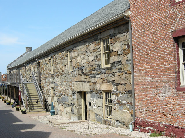
An old, very cool stone building.


Bristol is known for their 4th of July celebrations. Apparently it's a very big deal and they put a lot of effort into it. One street even has the centerline painted red, white and blue (if you're Japanese it's blue, white and red).


If it looks like a drug deal...